Proposal for Disposal of Surplus Land

Share Proposal for Disposal of Surplus Land on Facebook Share Proposal for Disposal of Surplus Land on X (formerly Twitter) Share Proposal for Disposal of Surplus Land on Linkedin Email Proposal for Disposal of Surplus Land link

At the Council meeting held on Wednesday 28 October 2026, Council resolved to give public notice of its intention dispose of land that are surplus to Councils needs.

Council officers have reviewed Council’s current land and building assets and identified several properties that are surplus to current and foreseeable operational requirements. These assets no longer support existing service delivery, strategic infrastructure, or future asset needs, and do not provide significant community benefit in their current state.

The proposed sales would enable Council to realise the value of underutilised assets, reduce ongoing maintenance and holding costs, and generate revenue that can be redirected towards priority projects, asset renewal programs and other strategic initiatives. The disposal aligns with asset management principles that support the optimisation of Council’s asset portfolio and the efficient use of public resources.

The proposed land for disposal are shown in the images below:
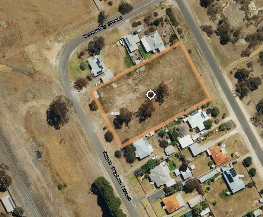
Upper Regions Street, Dimboola (98-104 Upper Regions Street, Dimboola CA 2 Section 22 & CA 3 Section 22)
This large double block is 4,052m2 in area and can be accessed from both Upper Regions Street and Ellerman Street. The land is located within the General Residential Zone in Dimboola and is subject to the Bushfire Management Overlay and Environmental Significance Overlay. The site was previously used as a municipal pound and may present opportunities for developers to construct multiple dwellings.
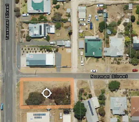
Rainbow (Corner of Norman and Taverner Street, Rainbow, CA 14M)
This 809m2 block is located within the Township Zone in Rainbow and is not subject to any planning overlays. The block contains mature trees and may provide an opportunity for future residential development, subject to the relevant planning and statutory requirements.
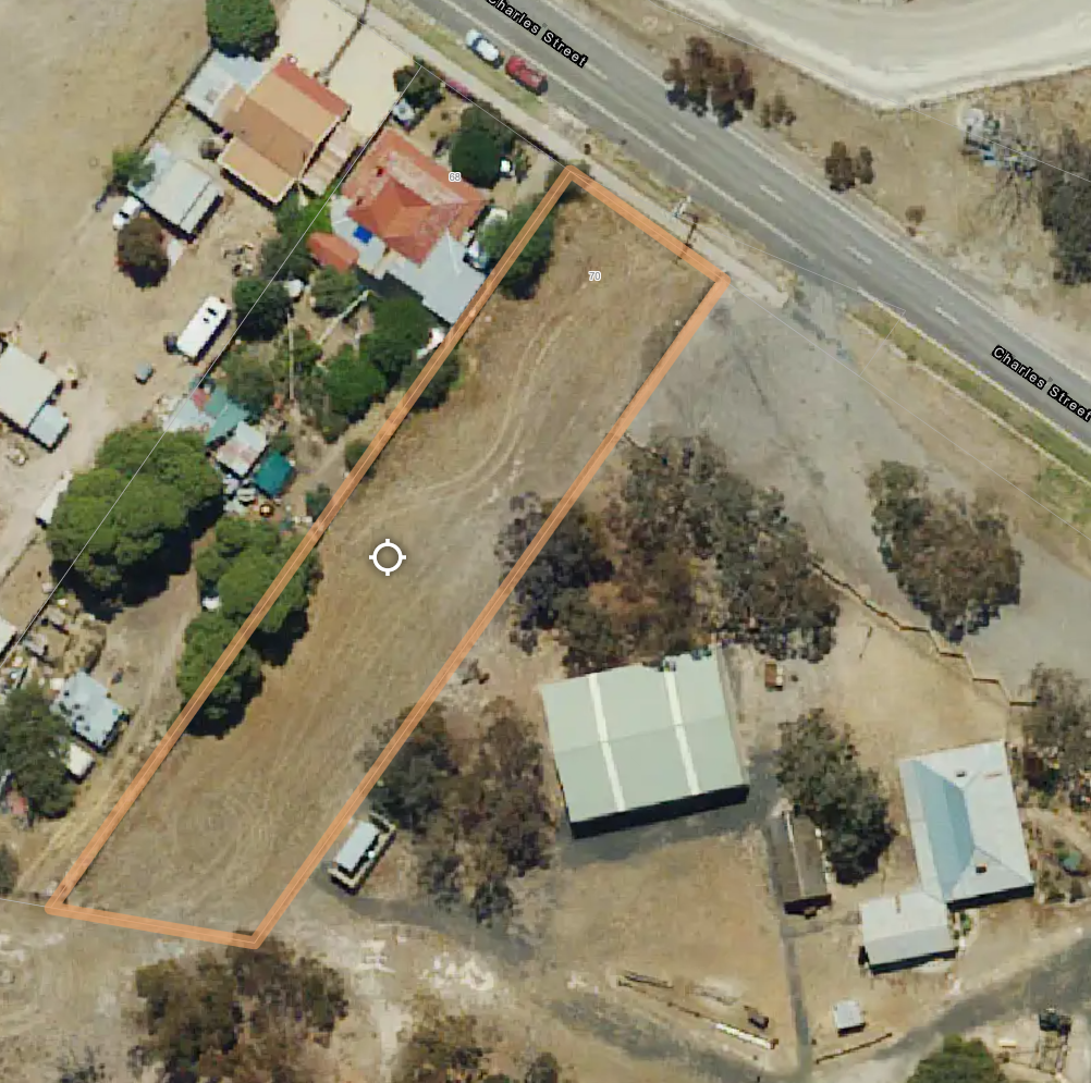
70 Charles Street, Jeparit (Lot 1 LP7980)
This block sits in a Township Zone with an approximately 20-meter-wide frontage and 1974 m2 area. It borders the Wimmera Mallee Pioneer Museum on the east side and a residential property on the west. The land is subject to a Bushfire Management Overlay, Environmental Significance Overlay, Flood Overlay and Land Subject to Inundation Overlay. A portion of eastern boundary is also designated as an Area of Aboriginal Cultural Heritage Sensitivity.
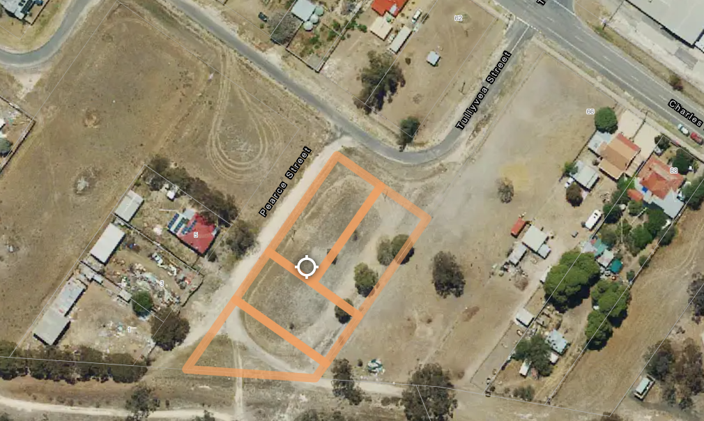
Riverside Street, Jeparit (Lot 1-4 LP12111)
Situated within a Township Zone, the block is 2,920m2 in area and is subject to the Bushfire Management Overlay, Environmental Significance Overlay, Flood Overlay and Land Subject to Inundation Overlay.
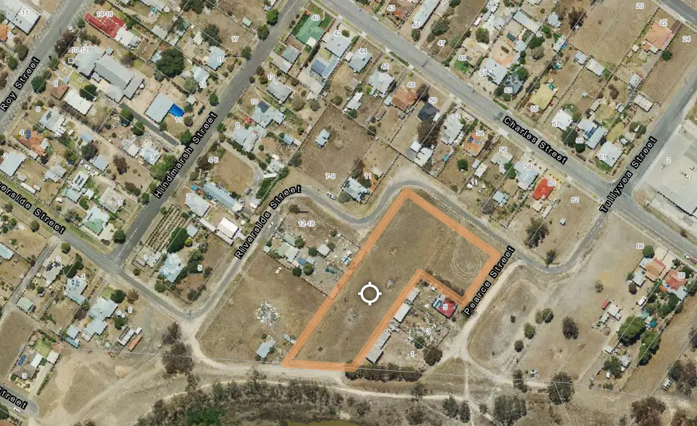
Riverside Street, Jeparit (Lot 8-9 LP12111, Lot 196 LP3581)
Situated within the Township Zone of Jeparit, this block is 6,865m2 in area and is subject to the Bushfire Management Overlay, Environmental Significance Overlay and Land Subject to Inundation Overlay. The block can potentially be utilised for residential development.

Feedback from You

Before Council progresses further with advertising these blocks of land for sale, we'd like to hear from you! Council invites you to complete the survey below to provide your feedback on this decision.

Please provide your feedback by 11:59pm on Friday 27 November 2026.

For further information or if you have any queries, please contact Mick Henderson, Manager Assets and Facilities, on (03) 5391 4444 or email mhenderson@hindmarsh.vic.gov.au.

At the Council meeting held on Wednesday 28 October 2026, Council resolved to give public notice of its intention dispose of land that are surplus to Councils needs.

Council officers have reviewed Council’s current land and building assets and identified several properties that are surplus to current and foreseeable operational requirements. These assets no longer support existing service delivery, strategic infrastructure, or future asset needs, and do not provide significant community benefit in their current state.

The proposed sales would enable Council to realise the value of underutilised assets, reduce ongoing maintenance and holding costs, and generate revenue that can be redirected towards priority projects, asset renewal programs and other strategic initiatives. The disposal aligns with asset management principles that support the optimisation of Council’s asset portfolio and the efficient use of public resources.

The proposed land for disposal are shown in the images below:

Upper Regions Street, Dimboola (98-104 Upper Regions Street, Dimboola CA 2 Section 22 & CA 3 Section 22)
This large double block is 4,052m2 in area and can be accessed from both Upper Regions Street and Ellerman Street. The land is located within the General Residential Zone in Dimboola and is subject to the Bushfire Management Overlay and Environmental Significance Overlay. The site was previously used as a municipal pound and may present opportunities for developers to construct multiple dwellings.

Rainbow (Corner of Norman and Taverner Street, Rainbow, CA 14M)
This 809m2 block is located within the Township Zone in Rainbow and is not subject to any planning overlays. The block contains mature trees and may provide an opportunity for future residential development, subject to the relevant planning and statutory requirements.

70 Charles Street, Jeparit (Lot 1 LP7980)
This block sits in a Township Zone with an approximately 20-meter-wide frontage and 1974 m2 area. It borders the Wimmera Mallee Pioneer Museum on the east side and a residential property on the west. The land is subject to a Bushfire Management Overlay, Environmental Significance Overlay, Flood Overlay and Land Subject to Inundation Overlay. A portion of eastern boundary is also designated as an Area of Aboriginal Cultural Heritage Sensitivity.

Riverside Street, Jeparit (Lot 1-4 LP12111)
Situated within a Township Zone, the block is 2,920m2 in area and is subject to the Bushfire Management Overlay, Environmental Significance Overlay, Flood Overlay and Land Subject to Inundation Overlay.

Riverside Street, Jeparit (Lot 8-9 LP12111, Lot 196 LP3581)
Situated within the Township Zone of Jeparit, this block is 6,865m2 in area and is subject to the Bushfire Management Overlay, Environmental Significance Overlay and Land Subject to Inundation Overlay. The block can potentially be utilised for residential development.

Feedback from You

Before Council progresses further with advertising these blocks of land for sale, we'd like to hear from you! Council invites you to complete the survey below to provide your feedback on this decision.

Please provide your feedback by 11:59pm on Friday 27 November 2026.

For further information or if you have any queries, please contact Mick Henderson, Manager Assets and Facilities, on (03) 5391 4444 or email mhenderson@hindmarsh.vic.gov.au.

Page last updated: 02 Nov 2026, 09:10 AM